Induced Seismicity Response
What is Induced Seismicity?
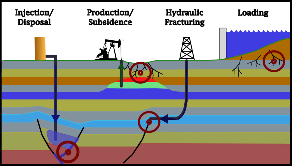
Induced seismicity refers to seismic events (i.e. earthquakes) that are triggered by human activity, such as Oil and Gas (i.e, injection/disposal [UIC] and hydraulic fracturing stimulation [HFS]), Mining, and Geothermal activities. These seismic events can occur when fluid is injected or extracted from the Earth’s crust too quickly, at too great of a volume, or generates too much pressure over time.
What is Induced Seismicity Monitoring?
Monitoring induced seismicity typically involves the use of seismometers (detects vibrations or movement within the earth), wellhead and/or downhole pressure monitoring, monitoring injected fluid volumes and rates, and determination of formation and fault line fracture gradients.
The data collected by both online sources (e.g., TexNet CISR, TXRRC, USGS, etc.) and provided by the client (i.e.: Daily injection Logs, Real-Time Monitoring Equipment, etc.) will be monitored and analyzed by geoscientists to identify potential risks and anomalies that may cause an induced seismic event. This information can help in decision-making processes, such as adjusting injection rates/volumes, implementing mitigation measures, or even shutting down operations for a time if necessary.


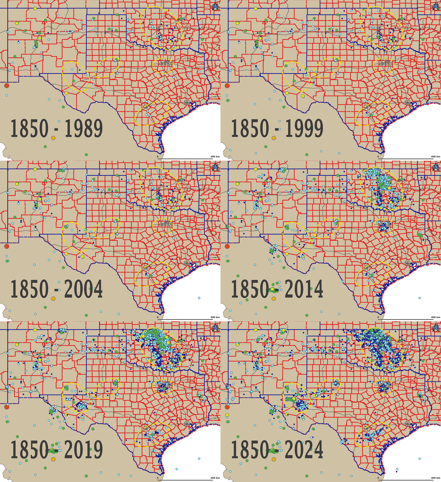
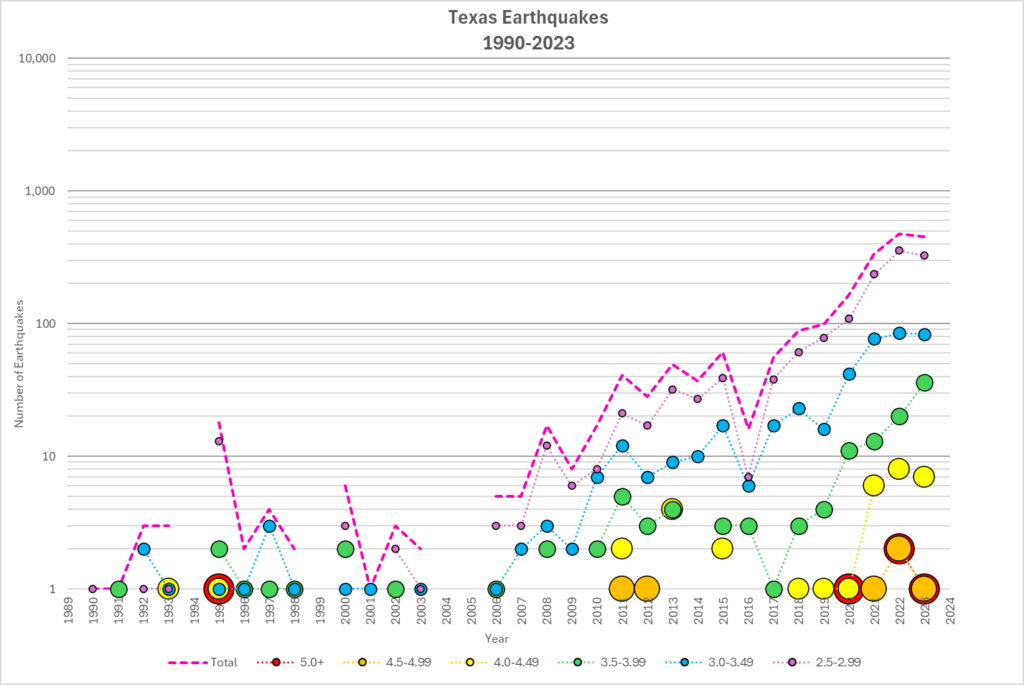
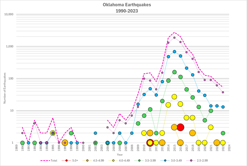
Texas and Oklahoma have had their share of naturally occurring earthquakes throughout known time. However, since 2009, there has been an increased seismic activity along with increasing earthquake magnitudes. This activity can be traced back to Oil and Gas operations, in particular the “Shale Boom” and the need to dispose of vast amounts of produced water.
Monitoring Services/Deliverables:
- Daily or Real-Time pressure and volume monitoring.
- Daily and Weekly reports and trend analysis.
- State and Federal seismic network review, documentation, and mapping.
- Compliance with regulatory requirements.
- Expert recommendations for risk mitigation strategies.
- Expert witness testimony.
- Liability reduction.
- Review Existing Data and Preliminary Route Planning.
B-geO’s Technical and Monitoring Capabilities:
- Existing Remote Monitoring Center (B-reaL Center) that has been in use for real-time drilling monitoring since 2020.
- Seismic Acquisition and Interpretation, which includes faults mapping/delineation using 3D seismic data.
- Real-Time Operations Support.
- Conducting After Action Reviews.
- Documenting and reporting anomalous or mission critical events, and timely client interaction.
- Review Existing Data and Preliminary Route Planning.


Client Benefits:
- Early detection and mitigation of potential over-pressurization.
- Daily to 24/7 monitoring of assets/wells for induced seismicity.
- Cost cutting by outsourcing monitoring and reporting activities.
- Real-time decision-making capability with preliminary interpretation of 24/7 data and daily reports.
- Ability to potentially prevent or reduce seismic activity.
- Review of nearby wells with analysis of FITs, LOTs, MWIN, ESDmin, ESDavg, ESGmax, etc.
B-geO MILESTONES
Below are some examples of our achievements
In 2008, we developed the first shallow hazards report submitted under new government regulations and approved by the Minerals Management Service (MMS) as part of the operators exploration plan.
In 2015, a Shallow Hazards Assessment (SHA) was completed and approved by the Bureau of Ocean Energy Management (BOEM) utilizing a seismic depth volume
Successful execution of field investigations is critically dependent of proper planning. In 2016 we facilitated a geophysical and ROV field program for a potential subsidence study in the deepwater Gulf of Mexico.
In 2016 the riserless section of a well was successfully drilled without any affect from significant shallow hazards based on our assessment of potential drilling conditions.
We are the exclusive provider of SHA work for several clients. This is based on our diligent work effort and timeliness.
